Main Info
This hiking safari takes you to Mountain Rwenzori National Park for mountain climbing.
Day One: Nyakalengija (1615m) – Nyabitaba Hut The Central Circuit starts at the RMS offices. After you should arrive in the morning to allow ample equipment and meet your guides and porters. The by passing througl1 farmland to the park boundary bl it follows the Mubuku river, crossing its Mahoma trib starting a long, steep climb up onto a massive ric Nyabitaba hut. Th-e hike takes around 5 hours.
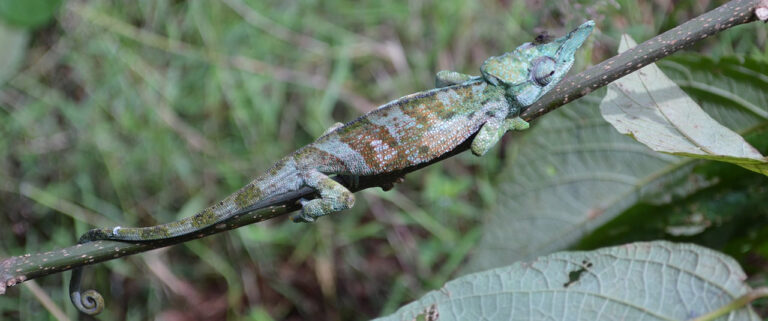
During this part of the trip you may hear chim see black and white colobus, blue monkey and t coloured Rwenzori turaco.
Day Two: Nyabitaba (2651 m) – Mubuku River (2l Matte Hut (3505m) This involves a demanding 7+ hour trek up to Johl The Central Circui t ‘proper’ starts a few hundred mE Nyabitaba where the trail divides. The right fork I peaks up the Bujuku valley while the path on the le1 the subsequent descent.
The trail leads to the Kurt Shafer Bridge which Mubuku valley just below the river’s confluence wit I valley. Beyond the river, a muddy, slippery trail clir up through bamboo forest.
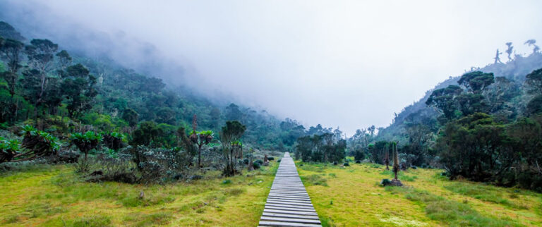
After a five hour trek is the start of the giant lobelia ar zone, a vegetation type limited to East Africa’s highes The final hour’s walk to John Matte hut passe! Challenging bog full of extraordinary plants!!
Day Three: John Matte (3505m) to Bujuku (3962m) The route fords the Bujuku River as you cross the bog, A steep clim b follows to reach the Upper Bigc a boardwalk has been constructed to assist walkE weather, there are superb views of Mt. Stanley at this cavernous, glacier-carved valley. Above the bog steady climb ovell” glacial moraine, criss-crossing t trail reaches the lovely Lake Bujuku. The last stage of the 3-5 hour hike to Bujuku Hut past Cooking Pot Cave is perhaps the muddiest stage of the expedition. The hut is well placed for parties climbing Mt. Speke.
Day Four: Bujuku (3962m) – Scott Elliott Pass (4372m) Kitandara (4023m) From Bujuku hut, the trail crosses more mud before climbing steeply through a forest of giant groundsels, climbing a short metal ladder to ascend the Groundsel Gully. Above the gully, a branch in the trail climbs directly to Elena Hut (4430m) for the ascent of Margherita peak on Mt. Stanley (5109m). This climb needs an ice axe, mountain boots, crampons and ropes.
The main trail continues up a steep scree slope over Scott Elliot pass, the highest point on the circuit. The pass provides fabulous views back down the Bujuku valley and of Mts. Stanley and Baker towering above. Beyond the pass, the route runs downhill beneath the massive cliffs of Mt. Baker. After passing Upper Lake Kitandara, the 3-5 hour hike ends at the hut beside Lower Lake Kitandara, a beautiful site surrounded by towering peaks.
Day Five: Kitandara (4023m) – Freshfield Pass (4282m) – Guy Yeoman (3505m) Freshfield is a long flat traverse through tracts of fabulously colourful moss (and more mud), beyond which the long descent to Nyakalengija begins. The hike to Guy Yeoman hut takes around 5 hours. The hut enjoys a lovely location close to the Mubuku River with terrific views of the looming Mt. Baker to the north.
Day Six:/Seven: Guy Yeoman (3505m) – Nyabitaba (2651 m) The descent to Nyabitaba takes around 5 hours but with an early start it is possible to make it all the way down to Nyakalengija. Below Guy Yeoman, the route descends the cliffs of Kichuchu. Beyond Kichuchu the muddy path crosses the Mubuku River twice before climbing upwards to Nyabitaba to complete the circuit.
Day Seven: Nyabitaba (2651m) – Nyakalengija (1615m) The descent from Nyabitaba to Nyakalengija takes 2-3 hours.
Trip Information
The official start days for treks are Mondays, Wednesdays and Fridays. However on the ground in Kasese depending on the traffic on the mountain and the booking situation people are starting their climbs outside of the official start days. Shorter duration visitors are being offered the possiblity to trek either in a clockwise or anit-clockwise direction. It is usual to trek in a clockwise direction for those on the 7 day circuit trail and those climbing some of the peaks. This ‘managerial flexibility’ in Kasese obviously leads to congestion at various huts so having a tent as back up accommodation would be in your interest. Trekkers/climbers prolonging their trips especially at Elena hut due to poor weather magnifies the over crowding situation on the mountain (a new hut is to be constructed at Elena in the near future). If you need that extra window of time it is recommended at the time of booking your intentions are made known. Put yourself in the situation of arriving at a hut expecting the use of accommodation only to find it fully occupied. Take a tent if you need the flexibility in your itinerary so as not to compromise the quality of the experience of other trekkers following in your footsteps.
Best Time to Visit:
Avoid the rain seasons at all costs. The Rwenzori is one of the main watersheds of the Nile receiving rain throughout the year but exceptional amounts from March through till June and September through December.
MOUNTAINEERING TIPS FOR HIKERS
Health and safety on the trail Hikers should familiarize themselves with the symptoms and treatment of hypothermia and the various forms of altitude sickness (see Osmaston’s Guide to the Rwenzori). Above 2500m, altitude sickness can affect anyone, irrespective of age, fitness or previous mountain experience. The most effective treatment is descent to a lower altitude.
Good behaviour at the huts and on the trail is appreciated · The park operates a ‘Leave no trace’ policy. Collect all waste and make sure you or your porters take it out of the park.
Please use the latrines provided at huts.
- Respect others in the huts by sharing space at the stoves and talking quietly.
- Observe the prohibition on wood fires which degrade the park’s vegetation. Gas cookers are provided by Rwenzori Mountineering Services.
- During periods of bad weather, it may be necessary to wait more than one night at huts to ease congestion ahead.
- Minimise damage to the trails by following your guide closely and avoid making new paths.


